Floodplain Management
Contents
Basic Information About Floodplains and Floodplain Management
Storm Preparation and Flood Recovery Tips
The National Flood Insurance Program
Community Rating System (CRS) Program
Floodplain Development
Flood Zone Classifications and Flood Zone Maps
Floodplain Management Frequently Asked Questions (FAQ)
Helpful Links & Resources
Introduction
This webpage provides more information about floodplain management. It also describes Atlanta’s floodplain management activities in detail. The table of contents at the top of this page provides an overview of the available information, as well as quick access to each topic. The Department of Watershed Management will regularly check this website to ensure that hyperlinks remain accurate. Further, the Department will review and update, at least annually, the content to ensure that it is current and relevant. Please direct any questions, or requests for more information to the City’s Floodplain Administrator at 404-546-3291 or crethwilm@atlantaga.gov.
Basic Information About Floodplains and Floodplain Management
What is the floodplain?
The non-technical and simplified definition of a floodplain is “an area adjacent to a body of water.” But using this definition to determine if your property is in a floodplain is deceiving. You may be located five miles or more from a river or stream and find your house covered with flood waters. Floodplains have varying characteristics and may not be easily identified. In fact, communities experiencing large population growth can create a floodplain where none previously existed. In many of Atlanta’s urban areas, past development transformed old streams and creeks by forcing those surface waters into pipes; but the associated floodplains often function as though a stream or creek still existed. In Atlanta, these areas are called “Historically Modified Floodplain”
What is the “Special Flood Hazard Area”?
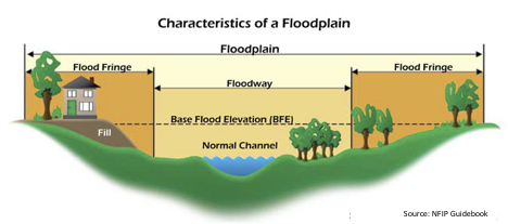
The Special Flood Hazard Area (SFHA) is an area of high flood risk that is inundated by the 1% annual chance flood, sometimes referred to as the 100-year flood or base flood. The SFHA is often referred to as the Floodplain. These areas are indicated on the National Flood Insurance Program (NFIP) Flood Insurance Rate Maps (FIRMs) that are available on FEMA’s Map Service Center: https://msc.fema.gov/portal/
What is the Base Flood?
The base flood, sometimes referred to as the 100-year flood, has a 1% chance of occurring in any given year. Although a 100-year flood sounds remote, keep in mind that over the life of an average 30-year mortgage, a home located within the 100-year flood zone (see below for flood zone definitions) has a 26% chance of being inundated by the base flood. This same home has less than a 1% chance of fire damage during the same period. The National Weather Service (NWS) and the National Oceanic and Atmospheric Administration (NOAA) have more information about rainfall frequency and volumes.
What is the floodway?
The floodway includes the channel of a river or stream and the overbank areas adjacent to the channel. The floodway carries the bulk of the floodwater downstream and is usually the area where the speed and depth of flood waters are the greatest and most destructive. Regulations require that the floodway be kept open so that flood flows are not obstructed or diverted onto other properties.
What is the flood fringe?
The area on either side of the floodway is called the flood fringe. This area is subject to inundation by the base flood but conveys little or no velocity flows.
How does fill affect the floodplain?
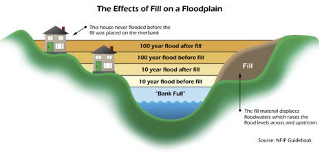
By nature, floodplains are low-lying areas that seem to invite filling activities. Filling is included under the NFIP definition of “development” and therefore requires a floodplain development permit. Filling in the floodplain nearly always alters natural drainage patterns, diverts flood waters to other properties, or affects endangered species or their critical habitat. The City of Atlanta prohibits any filling in the floodplain.
What are the natural functions of the floodplain?
Floodplains have many positive impacts on the environment. During large rainfalls, the creeks within Atlanta cannot handle the full volume of flow within the stream banks. The extra volume from these large rainfalls will naturally overflow into the floodplain, temporarily storing the floodwaters and reducing the impact on downstream residents. For this reason, protecting and managing floodplains is a top priority for the City of Atlanta: it improves the health of Atlanta’s creeks, minimizes property damage, and minimizes loss of life.
Floodplains improve the water quality of Atlanta’s streams and creeks through several processes. Stormwater runoff must first flow through the floodplain before entering the creek. As the water flows through this vegetated area, sediments and dissolved pollutants are filtered by the plants and the soil. Floodplains also allow stormwater to slow down before flowing into the stream, resulting in less stream bank erosion and less sediment in streams. Sediment is a one the leading causes of water quality impairment in Atlanta.
When streams overtop their banks and spill into the floodplains, unique habitat environments are formed. For example, after the water recedes to the normal stream channel, shallow pools formed in the floodplain provide habitat for tadpoles, frogs, salamanders, and other riparian wildlife. Floodplains are ecosystems that survive only through a delicate balance of rising and falling waters. When floodplains are modified, the balance is altered and the vegetation and wildlife that thrive in the floodplains may no longer be able to survive in the new habitat.
Storm Preparation and Flood Recovery Tips
Know your Flood Hazard
The City of Atlanta developed along the Eastern Continental Divide, at the crossing point of railroad lines built along the ridge of the Divide in the 1800s. Because of this location, downtown Atlanta is situated at the headwaters of several watersheds. In fact, the watersheds originating within the City’s borders are part of three river basins: the Chattahoochee, the Flint, and the Ocmulgee Rivers.
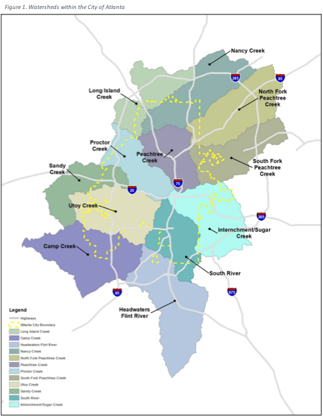
Atlanta has portions of 12 watersheds as illustrated in Figure 1. The watersheds on the western side of the Eastern Continental Divide are Long Island Creek, Nancy Creek, Peachtree Creek (including the North Fork Peachtree Creek and the South Fork Peachtree Creek), Proctor Creek, Utoy Creek, Camp Creek, and Sandy Creek. The watersheds on the eastern side of the Eastern Continental Divide are Intrenchment Creek, Sugar Creek, South River, and the Flint River. (The Intrenchment Creek Watershed and the Sugar Creek Watershed are shown as one combined watershed on the maps due to the small amount of the Sugar Creek watershed within the city limits.)
In Atlanta, five types of flooding may occur: (1) riverine, (2) flash, (3) ponding, (4) backwater, and (5) urban.
Riverine flooding occurs along a river or smaller stream. It is the result of runoff from heavy rainfall or intensive snow or ice melt. The speed with which riverine flood levels rise and fall depends not only on the amount of rainfall, but even more on the capacity of the river itself and the shape and land cover of its drainage basin. The smaller the river, the faster water levels rise and fall. Generally, elongated and intensely developed drainage basins will reach faster peak flows and faster falls than circular-shaped and forested basins of the same area. The Chattahoochee River is a relatively large river and thus it rises and falls more slowly due to its large bankfull capacity.
Flash flooding occurs when a locally intense precipitation inundates an area in a short amount of time, resulting in local streamflow and drainage capacity being overwhelmed. Ponding occurs when concave areas (e.g., parking lots, roads, and clay-lined natural low areas) collect water and are unable to drain.
Backwater flooding occurs when water slowly rises from a normally unexpected direction where protection has not been provided. A great example of this type of flooding is when stream flows are larger than a culvert under a road can handle or a culvert is blocked by trash and debris and the water backs up behind the culvert.
Urban flooding is similar to flash flooding but is specific to urbanized areas. It takes place when storm water drainage systems cannot keep pace with heavy precipitation, and water accumulates on impervious surfaces and in small depressions. Most urban flooding is caused by slow-moving thunderstorms or torrential rainfall.
The City of Atlanta, like other urban areas, faces risks to life and property from many natural and man-made hazards, including: fire, tornados, terrorism, toxic spills, wind, drought, wildfire, and flood. Of all these risks, flooding is arguably the greatest threat to the residents of Atlanta.
Your property may be subject to flooding. You can call or email the City’s Floodplain Administrator for details specific to your property. Information such as your current flood zone, local floodplains, and basic flood preparedness tips are available. To report flooding call ATL311 (404-546-0311) or visit https://www.atl311.com/. In case of extreme flooding or other conditions that pose a safety hazard, please also contact Police and Fire Emergency at 911.
Stay Informed about potential and current flooding
Get alerts about emergencies and other important news by signing up for the City’s Emergency Alert Program, NotifyATL. This system enables the city to provide you with critical information quickly in a variety of situations, such as severe winter weather, unexpected road closures and evacuations of buildings, as well as community events. You will receive real-time messages however you specify, such as to your home, mobile or business phone, by text message and more. You pick where. You pick how. Click here to sign up today!
On Social Media: Follow DWM for real-time information:
• https://www.atlantawatershed.org/
• Facebook: https://www.facebook.com/atlwatershed/
• Twitter: https://x.com/atlwatershed
• YouTube: https://www.youtube.com/atlwatershed
Stay tuned to local radio, TV stations, and weather websites to stay informed during a significant weather events:
• National Weather Service – https://www.weather.gov/
• WSB 2 – https://www.wsbtv.com/
• Fox 5 – https://www.fox5atlanta.com/
• CBS 46 – https://www.cbs46.com/
• 11 Alive (NBC) – https://www.11alive.com/
• WABE (NPR) – https://www.wabe.org/
Know the Warning Signals
• Sign up for Alerts – Receive emergency alert information on your phone or via email from the City and local new sources.
• Listen for Sirens – In the case of emergency, police and fire officials will use their sirens and loudspeakers to alert you to necessary information about the emergency.
• Turn on your TV or radio – During large storms events, tune into a local station to find out information about emergency and evacuation routes. The emergency broadcast station for Sacramento is KFBK Radio 1530-AM.
Know Your Flood Terms
• Flood Watch = Be Aware
1. Turn on TV/radio.
2. Know where to go.
3. Have your emergency kit ready
• Flood Warning = Take Action
1. Move immediately to higher ground or stay on high ground.
2. Evacuate if directed.
3. Avoid walking or driving through flood waters.
Be Prepared
1. Make a Plan. Then practice, practice, practice.
a. Choose an emergency contact – Family members will contact this person in an emergency to let them know they are safe. A friend or family member out of town may be easier to reach in an emergency. Make sure everyone knows how to contact the emergency contact
b. Make sure everyone knows how to contact the emergency contact
c. Know emergency contact numbers – Post them near your home phone & save them in your cell phones
d. Choose multiple meeting places – choose locations that are on high ground but easily accessible for all family members
e. Sign up for a local emergency alert system such as the City of Atlanta’s NotifyATL, ReadyGeorgia, or alerts from your local news station(s).
2. Be Safe!
a. Turn Around, Don’t Drown!® – Avoid walking or driving through flood waters. Just 6 inches of moving water can knock you down, and two feet of water can carry away your vehicle.
b. If floodwaters rise around your car but the water is not moving, abandon the car and move to higher ground. Do not leave the car and enter moving water.
c. Avoid camping or parking along streams, rivers, and creeks during heavy rainfall. These areas can flood quickly and with little warning.
Assemble an At Home Emergency Kit
1. In an emergency, you may not have access to food, water, or electricity for several days. Prepare an emergency kit last will last you at least 3 days. Remember to tailor the kit so it works for your family!
a. Food – choose foods that are easy to make and will not spoil (Don’t forget the fur family members!)
b. Water – 1 gallon per person per day
c. Manual can opener
d. First-aid supplies
e. Blankets
f. Matches/Lighter – store in a sealed plastic container
g. Flashlight & Batteries
h. Special Need Items – Medical needs, baby and pet needs
i. Print a copy of this Emergency Kit Checklist to help you prepare.
“Grab & Go” Bag
1. If you have to evacuate in a hurry, a grab & go bag will be very helpful. Fill a durable bag, with necessary items such as:
a. Food & Water
b. First-Aid Supplies
c. Personal Care Items
d. Flashlight, Radio, & Batteries
e. Cell Phone charger
f. Copies of Important Documents (store in a double zipped freezer bag for protection)
g. Extra Cash, map of the area, & extra keys of house & car
h. Unique family needs – baby needs, pet needs
Each family is unique. Pack things that make sense for your family. If you have children, get them involved! They can add one of their favorite games to the kit to keep the family occupied during stressful situations.
For Your Car
1. An emergency can happen anywhere at anytime. Keep a small emergency kit in your car in case of emergency during your commute.
2. Make sure to have extra gas, a blanket, window breaking hammer, etc.
3. Check your tire treads and windshield wipers and consider replacement if needed.
Recover
Consider following these steps if you recently experienced flooding:
1. Call your insurance company
a. Notify your insurer as soon as possible
b. Work with your insurer to determine the extent of your coverage
2. Avoid additional risk
a. Check for visible structural damage
b. Contact your utility company if you suspect damage to your utilities
c. Turn off all water and electrical sources; DO NOT attempt to turn off electricity while standing in water. Get professional help!
3. Take pictures
a. Fully document the damage before any repairs are made
4. Protect your health
a. Wear protective clothes: boots, gloves, mask etc.
b. Remove all contaminated food
5. Remove the water
a. When instructed by your insurer, pump the water out of your house
b. Sump pumps are available from most hardware stores for $150-$500
c. Wet vacs average $40-$130
d. Open doors and windows to allow fresh air to circulate
6. Make floodproofing a priority when you rebuild
a. Consider structural changes to your home
b. Add flood openings at the base of the structure or along walls
c. Elevate appliances like your AC unit or water heater
The National Flood Insurance Program
The National Flood Insurance Program (NFIP) was established by the National Flood Insurance Act of 1968. The NFIP is a federal program enabling property owners in participating communities to purchase flood insurance as protection against damage from floods, while requiring state and local governments to enforce floodplain management ordinances that aim to reduce future flood damage. The NFIP exists to transfer the cost of flood damages from the public to the private sector. It does so by providing federal flood insurance to property owners and by requiring communities to adopt and enforce floodplain management regulations.
Community participation in the NFIP is voluntary. When a community joins the NFIP, the community must ensure that it has adopted a floodplain management ordinance and enforcement procedures that meet NFIP minimums. In return, the federal government makes flood insurance available for residents of that community. The NFIP requires that community ordinances be legally enforceable and uniformly applied throughout the community. NFIP guidance and policies are reviewed periodically and revised when appropriate. When any changes are made or when Flood Insurance Rate Maps (FIRMs) are updated, community floodplain management ordinances also must be revised and updated accordingly. Access to certain disaster aid, grants and loans is also made available to NFIP participating communities. You can visit the official website of the National Flood Insurance Program (NFIP) at https://www.floodsmart.gov/.
Most homeowner insurance policies do not cover damages caused by flooding from storm events. Residents and business owners with property in a Special Flood Hazard Area (SFHA) in Atlanta are required to purchase flood insurance if they have a mortgage from a federally regulated or insured lender. Resident’s and business owner’s property outside floodplains or other areas with a high-risk of flooding should consider purchase flood insurance. This insurance coverage may be eligible for lower-cost Preferred Risk Policies.
More than 22,100 communities in the U.S. participate in the NFIP and more than 5.1 million NFIP policies are in force, providing $1.25 trillion of content and building coverage. In Georgia, there are 577 participating communities in all of the State’s 159 counties. There are 76 communities with mapped SFHAs that are not participating. Atlanta joined the NFIP in the 1970s and has restricted development in the floodplain since that time.
Helpful links to more information:
• Purchasing NFIP flood insurance
• FEMA policyholder letters
• Information for state & local officials
• Information for surveyors
• NFIP insurance reform
Community Rating System (CRS) Program
The Community Rating System (CRS) is a voluntary program for communities participating in the National Flood Insurance Program (NFIP). The goals of the CRS are to reduce flood damages to insurable property, strengthen and support the insurance aspects of the NFIP, and encourage a comprehensive approach to floodplain management.
The CRS was developed to provide incentives in the form of premium discounts for insurable property in communities that go beyond the minimum floodplain management requirements and develop extra measures to provide protection from flooding. The CRS is similar to—but separate from— the private insurance industry’s programs that grade communities on the effectiveness of their fire suppression and building code enforcement efforts.
CRS discounts on flood insurance premiums range from 5% up to 45% based on CRS credit points that are awarded to communities. The discounts provide an incentive for communities to implement new flood protection activities that can help save lives and property when a flood occurs. Discounts apply to NFIP policies in the Special Flood Hazard Area (SFHA) and some policies located outside of a SFHA.
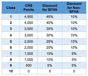
The City of Atlanta is currently classified as a Class 7 Community in the CRS. As result, properties in the City of Atlanta are eligible for a fifteen percent (15%) discount on the typical cost of flood insurance because the City participates in the Community Rating System (CRS) program. There are some restrictions regarding this discount and properties owners must verify eligibility through their insurance agent based on the configuration and elevation of the lowest floor of their structure.
The City’s Floodplain Administrator provides general floodplain information free of charge to City residents to assist them in determining if their properties are affected by floodplains. If needed for insurance or other purposes, a resident can obtain an official floodplain letter of determination from the City’s Floodplain Administrator.
More information is available on the Federal Emergency Management Agency (FEMA) website, www.fema.gov or at the National Flood Insurance Program website, www.floodsmart.gov. You may also contact your mortgage lender, insurance company, or the City’s Floodplain Administrator for more specific information.
Craig Rethwilm, PE, CFM
404-546-3291
crethwilm@atlantaga.gov
Floodplain Development
Any development in the floodplain within City limits needs local or state permits. The City of Atlanta’s floodplain ordinance has special provisions regulating construction and prohibiting new development within floodplains. Without these provisions, flood insurance through the National Flood Insurance Program (NFIP) would not be available to residents in the City of Atlanta.
New development in the floodplain is illegal. Non-compliant redevelopment within the floodplain can result in the City’s probation or possible suspension from the NFIP. This can result in substantially higher rates within the city for purchasers of flood insurance. Therefore, all work proposed within a designated flood hazard area requires a permit to ensure compliance with floodplain regulations.
Specific information about development in floodplain areas is available by calling the Floodplain Administrator (404-546-3291) or the Department of Watershed Management’s Office of Site Development (404-330-6249).
Details for picket fences and gates in the floodplain can be found here.
Floodplain Regulations
The City’s Floodplain Ordinance is posted on the Municode webservice and may be viewed by clicking here.
More detailed information about floodplain regulations is available from the Department’s Office of Site Development. Visit the Site Development webpage here, or call 404-330-6249.
The National Flood Insurance Program and federal law established the minimum criteria for floodplain management ordinances. According to the Emergency Management and Assistance regulations enacted by FEMA, the following minimum criteria must be included in a local floodplain management ordinance (See Title 44, Chapter I, Subpart B of the Code of Federal Regulations for more information):
• Section 59.1 Definitions
• Section 60.3 Floodplain Management Criteria for Flood-prone Areas
• Section 60.6 Variances and Exceptions
Grandfathering Rules
Properties located within the floodplain may be affected by changes to the official FIRMs. Grandfathering is a way for insurance agents to offer property owners cost saving options through the NFIP. FEMA has published a guidance document designed to provide an overview and examples of the NFIP’s Grandfather Rules on how these rules can be applied to benefit eligible residence and business owners being affected by map changes.
Substantial Improvement & Substantial Damage
After a flood damages businesses and homes, many property owners will want to rebuild or repair their property. However, when improvements to existing buildings, structures, and manufactured homes meet the definition of “substantial improvement,” or when damage meets the definition of “substantial damage” (SI/SD for short), the City of Atlanta must enforce requirements to bring those structures into compliance by meeting the requirements for new construction. The SI/SD requirements grew out of the recognition that there were large numbers of buildings and manufactured homes already located in floodprone areas before communities joined the NFIP.
To administer the SI/SD requirements, the City of Atlanta will take four actions:
1. Determine the cost of the proposed work;
2. Determine the market value of buildings;
3. Make SI/SD determinations and provide determinations to property owners; and
4. Require owners to obtain permits to bring substantially improved and substantially damaged structures into compliance with the floodplain management requirements.
Property owners may appeal decisions by providing additional information, especially when estimates of costs and market values are used to make determinations.
If work on buildings constitutes SI/SD, then structures must be brought into compliance with NFIP requirements for new construction, including the requirement that lowest floors be elevated to or above the base flood elevation (BFE) as required by local floodplain ordinance. Meeting this requirement can also be accomplished by demolition followed by construction of new buildings that meet the NFIP requirements on the same sites or by relocating buildings to locations out-side of the SFHA. In some cases, after a disaster, communities have worked with owners to buy damaged homes to demolish the buildings and preserve the land as open space
What is Substantial Damage (SD)?
Substantial damage, as defined by FEMA, means:
• Damage of any origin sustained by a structure whereby the cost of restoring the structure to its before-damaged condition would equal or exceed 50 percent of the market value of the structure before the damage occurred.” Most damage occurs during a single and sudden event, such as a fire, wind storm, lightning strike, falling tree, tornado, earthquake, flood, or natural gas explosion. Damage may also be unrelated to a specific event, such as soil settlement, exposure to the elements, termite infestation, vandalism, deterioration over time, and other causes.
What is Substantial Improvement (SI)?
Substantial improvement, as defined by FEMA means::
• Any reconstruction, rehabilitation, addition, or other improvement of a structure, the cost of which equals or exceeds 50 percent of the market value of the structure before the start of construction of the improvement. The term includes structures that have incurred “substantial damage,” regardless of the cause of damage and regardless of the cost of repair work actually performed.
However, “substantial improvement” does not include:
• Any project for improvement of a structure to correct existing violations of State or local health, sanitary, or safety code specifications that have been identified by the local code enforcement official, and that are the minimum necessary to ensure safe living conditions; or
• Any alteration of a “historic structure,” provided that the alteration will not preclude the structure’s continued designation as a “historic structure.”
In the City of Atlanta, the SI/SD amount is a cumulative total over any given 10-year period. The value determination includes only the structure itself, not the value of the land underlying the structure.
How to Determine if a Structure is in a Flood Zone
If a structure is fully within a flood zone, the floodplain regulations apply. If a structure is touching a flood zone at all, as shown on a FEMA Flood Insurance Rate Map (FIRM), the floodplain regulations apply. This means any update, renovation, or repair to the structure—including painting, interior remodeling, new flooring, or other change—requires a permit. The value of these renovations will count toward the ten-year cumulative total for an SI/SD determination. However, if a flood zone overlaps your property but does not overlap a structure, the structure may not be subject to the floodplain regulations.
Contact the City’s Floodplain Administrator at 404-546-3291 if you have any questions or need clarification on anything concerning floodplains or an official determination regarding flood zones. FEMA’s Flood Map Service Center has interactive maps where property owners can search a street address or browse maps to see if a structure or property is within a flood zone at: msc.fema.gov/portal/home. The Georgia Flood Map Program is another resource with interactive maps to search for specific addresses and view floodplain locations. Visit the website at www.map.georgiadfirm.com.
Elevation Certificates
An elevation certificate is a document that lists a building’s location, lowest point of elevation, flood zone and other characteristics, according to the Federal Emergency Management Agency (FEMA). In short, the certificate shows the elevation of your property and the structures on your property compared to the base flood elevation on a flood map. This certificate is used only to certify building elevations. A separate certificate is required for floodproofing.
A FEMA Elevation Certificate (EC) may be required to obtain a permit for renovations performed on a structure located within a floodplain. This certificate may be found here: https://www.fema.gov/library/viewRecord.do?id=1383. Elevation Certificates must be completed by a professional engineer or land surveyor.
If you’re purchasing a home, you may also want to ask the sellers to give you its elevation certificate, if they have one, or to provide it before your closing. Likewise, if you’re building a new home in an area that has a high risk of flooding, the builder may have been required to obtain an elevation certificate, which you can ask them to give you. If your builder cannot provide the EC, there are other ways you can obtain one.
Because the City of Atlanta participates in the NFIP, the City keeps a record of all Elevation Certificates it has received: your home or business may already have an Elevation Certificate. Please contact the Department’s Floodplain Administrator at 404-546-3291.
Additional guidance can be found in FEMA Publication 467-1, Floodplain Management Bulletin: Elevation Certificate, available on FEMA’s website at www.fema.gov/media-library/assets/documents/3539?id=1727.
Floodproofing Certificates
Floodproofing of non-residential buildings may be permitted as an alternative to elevating to or above the Base Flood Elevation. However, a Floodproofing Certification is required.
Under the NFIP, nonresidential buildings can be floodproofed up to or above the Base Flood Elevation (BFE). A floodproofed building is designed and constructed to be watertight (substantially impermeable to floodwaters) below the BFE. Floodproofing a residential buildings is not permitted under the NFIP unless FEMA has granted the community an exception for residential floodproofed basements. The community must adopt standards for design and construction of floodproofed basements before FEMA will grant a basement exception. For both floodproofed non-residential buildings and residential floodproofed basements in communities that have been granted an exception by FEMA, a floodproofing certificate is required. Floodproofing a residential building does not alter a community’s floodplain management elevation requirements or affect the insurance rating unless the community has been issued an exception by FEMA to allow floodproofed residential basements.
To clarify, floodproofing is NOT an alternative to required elevation of residential structures within the floodplain. Raising the structure above the Base Flood Elevation has been found to be the best practice to floodproof homes.
The Floodproofing Certificate form can be found at www.fema.gov/media-library/assets/documents/2748.
What are the Flood Zones?
Flood Zone Classifications and Flood Zone Maps
Everyone lives in an area with some flood risk—it’s just a question of whether you live in a high-risk, moderate-risk, or low-risk flood area. Each flood zone describes the flood risk for a particular area, and those flood zones are used to determine insurance requirements and costs.
Flood zones for the City of Atlanta are indicated the city’s flood maps.
Special Flood Hazard Areas (SFHAs) subject to inundation by the 1% annual chance flood:
The 1% chance flood (100-year flood), also known as the base flood, is the flood that has a 1% chance of being equaled or exceeded in any given year. Areas of Special Flood Hazard include Zones A, AE, AH, AO, AR, A99, V, AND VE. The Base Flood Elevation (BFE) is the water-surface elevation of the 1% annual chance flood.
ZONE A – No Base Flood Elevations determined.
ZONE AE – Base Flood Elevations determined.
ZONE AH – Flood depths of 1 to 3 feet (usually areas of ponding); Base Flood Elevations determined.
ZONE AO – Flood depths of 1 to 3 feet (usually sheet flow on sloping terrain); average depths determined. For areas of alluvial fan flooding, velocities also determined.
ZONE AR – Special Flood Hazard Areas formerly protected from the I% annual chance flood by a flood control system that was subsequently decertified. Zone AR indicates that the former flood control system is being restored to provide protection from the 1% annual chance or greater flood.
ZONE A99 – Area to be protected from 1% annual chance flood by a Federal flood protection system under construction; no Base Flood Elevations determined.
ZONE V – Coastal flood zone with velocity hazard (wave action); no Base Flood Elevations determined.
ZONE VE – Coastal flood zone with velocity hazard (wave action); Base Flood Elevations determined.
Other Flood Areas
ZONE X (Shaded) – Areas of 0.2% annual chance flood (500-year); areas of 1% annual chance flood with average depths of less than 1 foot or with drainage areas less than 1 square mile; and areas protected by levees from 1% annual chance flood.
ZONE X (Unshaded) – Areas determined to be outside the 0.2% chance floodplain. Also called “Unshaded X”
ZONE D – Areas in which flood hazards are undetermined, but possible.

What Are Flood Maps?
Flood maps show a community’s risk of flooding. Specifically, flood maps show a community’s flood zone, floodplain boundaries, and base flood elevation. Specifically, flood maps show flood zones, floodplain boundaries, and the base flood elevation. Property owners, insurance agents, and lenders can use flood maps to determine flood insurance requirements and policy costs.
Just because a structure is not located in a mapped flood zone does not mean that it cannot flood. Nearly 25% of all flood damage claims occur in structures that are NOT in a mapped floodplain! Because your flood risk changes over time, the National Flood Insurance Program (NFIP) and the Federal Emergency Management Agency (FEMA) work with communities across the country to identify and map flood risk on an ongoing basis.
If you’re interested in learning how to read a flood map or how often flood maps change visit FEMA’s Map Service Center or view FEMA’s Flood Insurance Rate Map (FIRM) Tutorial.
What is a FIRM?
FIRMs are type of flood map that identify the Special Flood Hazard Areas (SFHAs) and the potential flood risk levels for a given area. FIRMs are used to determine flood insurance requirements for structures and to assure that Citizens are aware of potential flooding in their area.
FIRMS are available in multiple locations and formats.
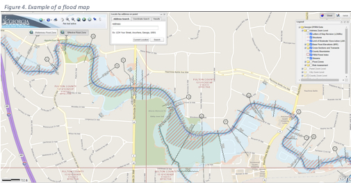
• The Georgia DFIRM (Digital FIRM) website has interactive, digital FEMA flood maps currently in force at www.map.georgiadfirm.com. The site is very easy to use and contains a wealth of information for property owners. The interactive map allows users to enter an address to retrieve property-specific flood risk information.
• Interactive, digital FIRMS are available at the FEMA Map Service Center website.
• Scans of paper flood maps may also be found at the FEMA Map Service Center website.
Why do flood maps change?
Flood hazards change over time. Updated flood maps provide a more accurate picture of a property’s flood risk. How water flows and drains can change due to new construction and community development or natural forces such as changing weather patterns or terrain changes. Also, communities may build levees and dams, decreasing flood risk over time.
To better reflect your current flood risk, the National Flood Insurance Program (NFIP) and the Federal Emergency Management Agency (FEMA) use the latest technology and data to update flood maps nationwide.
When did Atlanta’s flood maps change?
On August 16, 1999, the State of Georgia entered into a Cooperating Technical Partner (CTP) agreement with the FEMA’s Region IV. This agreement established that the State of Georgia is responsible for developing and updating FIRMs for all 159 counties in the State. Priority is usually afforded to communities with a history of flooding, communities with outdated maps, or communities anticipating or experiencing major development activity that may alter the flood risk in populated areas. The updated FIRMs and related products help the communities administer their floodplain management ordinances. The Floodplain Unit also receives FEMA funding to provide community outreach and assistance through a structured a community assistance program.
Part of the State’s Cooperating Technical Partner (CTP) agreement with FEMA, included a Map Modernization Program. The Map Modernization Program inventoried and analyzed the runoff generated with each of the City’s 4 drainage basins to current FEMA standards and criteria. This study developed new floodplain limits for the Base Flood Elevation (BFE) of the 100-year storm. The revised Flood Insurance Rate Maps (FIRM) and Flood Insurance Study (FIS) received final approval from FEMA in early 2013 and became effective on May 16, 2013. Further revisions to the FIS became effective December 8, 2016. Atlanta’s City-wide Letter of Map Revision (LOMR) (effective on February 20, 2008), including the Flood Insurance Rate Map (FIRM) panel maps, Flood Insurance Study (FIS) profiles and flow rate data issued for the City’s LOMR on February 20, 2008, was superseded by the FIRM and FIS approved by the Map Modernization Program.
The new floodplain maps can be used by individuals to view the extent of the floodplain’s impact on specific properties or within the City in general. All elevation certificates produced, as well as all surveys conducted to establish the limits of the floodplain on specific parcels of land on or after May 16, 2013, must utilize the data and elevation information contained with the revised FIRM and FIS issued by FEMA. Elevation Certificates must be prepared using the form in effect at the time of preparation, see the FEMA website for information on the form to be utilized. Detailed BFE data must be obtained from the Design, Environment & Construction Division and must be interpolated using the waterway Profiles in the FIS not the FIRMs.
Should you require additional information or clarification on the impact of the floodplain for any property within the City please contact the Department’s Floodplain Administrator at 404-546-3291.
Floodplain Management Frequently Asked Questions (FAQ)
General
• Is financial assistance available to homeowners who have experienced repeated flooding of their residences located in the floodplain?
If your home has experienced repeated and substantial damages from flood events, you may be eligible for a home buyout by the City of Atlanta, partially or fully funded by a FEMA mitigation assistance grant. Interested homeowners can refer to this Fact Sheet for more information and whom to contact. In addition, some NFIP policyholders may qualify for Increased Cost of Compliance (ICC) benefits to elevate your home above flood levels if flood-related claims exceed a certain threshold. More information on ICC is available at the FEMA website.
• Does the City of Atlanta Participate in the National Flood Insurance Program (NFIP) or the Community Rating System (CRS)?
Yes. Atlanta participates in both programs and is currently classified as a Class 7 community, earning citizens a 15% discount on flood insurance.
• Which Department at the City is responsible for Floodplain Management?
The Department of Watershed Management (DWM) administers the floodplain ordinance (Article VI, Chapter 74), the City’s participation in the CRS Program, and other related programs and policies.
• How does the DWM fund its floodplain management activities?
The City funds the administration of the floodplain management program through Water/sewer revenues—the fees residents pay for drinking water and sewer services. Other sources of funding include the Municipal Option Sales Tax (MOST) and grants.
• How can I find out who is responsible for flood control in my community?
The following cities & counties conduct their own floodplain management programs. Contact them directly regarding floodplain questions:
o City of Decatur
o Dekalb County
o Fulton County
Flood Insurance
• Why do I pay for flood insurance?
Flood insurance is mandatory if your home or property is within a special flood hazard area, as designated by the Federal Emergency Management Agency (FEMA) Flood Insurance Rate Maps, and you have a federally-backed or federally-insured mortgage. Your flood insurance policy covers your residence in the event it is damaged by flooding. Your homeowner’s insurance policy does not cover damage caused by flooding.
• How can I purchase flood insurance?
Flood Insurance can be purchased from the insurance agent who administers your homeowner’s insurance policy, any insurance company, or by visiting the FloodSmart website.
• Why do I need to purchase flood insurance if my property/residence is located within FEMA Zone X?
Typically, mandatory flood insurance is not required if your residence is located in Federal Emergency Management Agency (FEMA) Zone X, although your mortgage company may require you to have flood insurance if they believe there is a risk to your residence and they want to protect their interest.
• My home is in Zone X and I was told I couldn’t get flood insurance?
This is not correct! All residences are eligible for flood insurance even if they are located in a moderate-to-low risk flood area; for instance Zone X.
Contact the agent that administers your homeowner’s insurance policy to learn more or visit the FloodSmart website to get a list of insurance agents.
• Where can I find the definitions of all of the flood zones?
Definitions of FEMA flood zones can be found in the Flood Zone Classification and Flood Zone Maps section of this webpage or on FEMA’s website.
Floodplains
• Is my property in a Floodplain?
You can use the interactive maps at the Georgia Flood Map Program (map.georgiadfirm.com) or FEMA Map Service Center website to view and download detailed information about your property. You can also contact the Department’s Floodplain Administrator at 404-546-3291 for assistance determining whether your property is located in a Special Hazard Flood Zone.
If your property not located in the City of Atlanta or in a jurisdiction that does not perform floodplain management duties for, you may be referred to FEMA for more information.
• How do I get my property out of a floodplain?
Please contact the Department at 404-546-3291 for more information regarding the process and requirements for a Letter of Map Revision (LOMR) request to FEMA. A LOMR is for a formal determination of the property’s location and/or elevation relative to the Special Flood Hazard Area (SFHA).
• How do I get a copy of an Elevation Certificate?
The Department may have an Elevation Certificate if the structure is located in the City of Atlanta, and an Elevation Certificate was required when the structure was built. Residences may not have an Elevation Certificate on file. Please contact the Department’s Floodplain Administrator at 404-546-3291 for more information.
If you are not located within the boundaries of the City of Atlanta, contact the local jurisdiction in which the structure is located to inquire about record of the Elevation Certificate.
• How do I get an Elevation Certificate?
For new or existing structures that were recently identified as being in a floodplain, an Elevation Certificate is typically completed by a registered Land Surveyor or Professional Engineer. However, a homeowner or representative may complete the Elevation Certificate for Federal Emergency Management Agency (FEMA) Zones AO and A without a base flood elevation.
• How much does it cost to get an Elevation Certificate?
An Elevation Certificate can range from $400 -$1,000 depending on the complexity of the survey and size of your property. Please contact a registered Land Surveyor or Professional Engineer to prepare the Elevation Certificate.
• Why doesn’t the Department provide Elevation Certificates at no cost to citizens?
The Department will provide a copy of an Elevation Certificate, if one is on record, for a nominal fee to cover the cost of compilation and reproduction. However, an Elevation Certificate is the responsibility of the owner who initially builds the structure. It is used to show compliance with the approved site plan and provides documentation for obtaining flood insurance.
Permits
• What type of permit do I need?
Learn more about each permit type by visiting the City’s Licenses & Permits webpage at www.atlantaga.gov/doing-business/licenses-permits.
• How much does a permit cost?
The type of building permit and the associated fee depends on the type of construction, for example residential or commercial. You can complete a single, all-purpose form, and the Office of Buildings will inform you which permit(s) are necessary and next steps.
• Why do I need permission to build or grade on my property?
The Department enforces the Floodplain Regulations on all Special Flood Hazard Areas within the boundaries of the City of Atlanta in order to protect other residents and to minimize damage and losses due to flooding.
When development is proposed within these areas, it is the intent of the Department to take reasonable action and enforce regulations on development in Special Flood Hazard Areas in order to minimize the consequence of flooding and to prevent unwise development.
• What can I do if I believe my neighbor is making changes on their property that will eventually cause problems on my property?
If your neighbor has obtained an approved Floodplain Use Permit and/or Building Permit, it should minimize adverse impacts downstream. If the development is not permitted, or modifications to approved plans occur, you can report them to ATL311 by call 404-546-0311 or visiting www.atl311.com. All other potential floodplain violations that are not within the City of Atlanta should be directed to the applicable jurisdiction.
Property & Maintenance
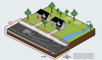
• Who is responsible for maintaining the creeks in my neighborhood?
It depends. The City of Atlanta is typically responsible for infrastructure within the public right-of-way, within existing easements, or on public property. All other components of the stormwater drainage system and other portions of creeks are the responsibility of the applicable property owner or home owners’ association (HOA). Please contact the Department by calling 404-546-0311 for assistance determining who is responsible for maintenance.
• How can I find out what property the Department owns throughout the city?
The City’s GIS database provides a huge variety of information. If you have questions as to specific properties or boundary lines, please contact ATL311 at 404-546-0311.
Rainfall & Weather
• What is a 100-year flood?
A 100-year storm refers to rainfall totals that have a one percent probability of occurring at that location in that year. Encountering a “100-year storm” on one day does not decrease the chance of a second 100-year storm occurring in that same year or any following year. In other words, there is a 1 in 100 or 1% chance that a storm will reach this intensity in any given year. Likewise, a 50-year rainfall event has a 1 in 50 or 2% chance of occurring in a year. In addition, each locality has its own criteria for how much rain must fall within 24 hours to classify as a particular rain event. See chart below for other rainfall events.
Likewise, there are similar classifications for 100-year flood events. The term 100-year flood is used in an attempt to simplify the definition of a flood that statistically has a 1-percent chance of occurring in any given year. The actual number of years between floods of any given size can vary because the climate naturally varies over time. Large floods or rain events can occur in successive or nearly successive years. It should be noted that not every 100-year rainfall event leads to a 100-year flood. Local circumstances may allow for a less severe storm to lead to severe flooding. The U.S. Geological Survey has a great explanation and more resources about rain events and flooding here. (Source: U.S. Department of Agriculture)
There are several stream gauges and rain gauges located throughout the City of Atlanta. The locations and data from these gauges are available on the U.S. Geologic Survey’s (USGS) webpage at https://ga.water.usgs.gov/precip/. Live streamflow, rain, and flood information is also available at USGS’s Current Water Data for Georgia webpage.
A Stream Gauge is a device used to measure the discharge, or the volume of water moving through a channel of a stream, per unit time. The height of water in the stream channel, known as a stage or gage height, can be used to determine the discharge in a stream. When used in conjunction with velocity and cross-sectional area measurements, stage height can be related to discharge for a stream. The USGS webpage also has a comprehensive description of how to read the stream gauge data and understand how it relays flooding information.
A Rain Gauge is a meteorological instrument that measures the precipitating rain in a given amount of time per unit of area. The instrument consists of a collection container which is placed in an open area. The precipitation is measured in terms of the height of the precipitated water accumulated in the container per given time and is expressed in millimeters. This volume can be used to understand the intensity of a storm and compare that to historical data and rain event return frequency estimates.
• Where can I find rainfall, streamflow, and weather data?
Historical weather data, including monthly rainfall totals can be access on the National Weather Service website at w2.weather.gov/climate. Information about streamflow conditions can be accessed via U.S. Geological Survey (USGS) Current Water Data for Georgia webpage waterdata.usgs.gov/ga/nwis/rt. The USGS also maintains nearly 300 rain gauges across the state; the data from these gauges can be accessed at the USGS’s Current Conditions for Georgia webpage waterdata.usgs.gov/ga/nwis/current.
The National Weather Service (NWS) and the National Oceanic and Atmospheric Administration (NOAA) have more information about rainfall frequency and event volumes.
Alternatively, some of this data may be available from the Department for a nominal fee to cover the cost of compilation and reproduction. Please call our Floodplain Administrator at 404-546-3291 for more information.
• Why are there more rain gages in some areas of the State than in others?
The density of rain gauges and the placement of individual gauges are based on a variety of factors, including:
o Environmental conditions;
o Flood Hazard Potential;
o Stream location;
o Permitting requirements;
o Proximity of other gauges; and
o Watershed boundaries
Storm Assistance
• Where can I report flooding that I see in my area?
If you are experiencing an emergency that threatens you or others’ safety, please call 911 for police, fire, and paramedics.
Please call ATL 311 to report street flooding, but only after you and your loved ones are safe.
• Where can I get sandbags to avoid flooding when a storm is predicted or during a storm?
Call your local Fire Department to see if they have sandbags and sand. Availability may depend on the rain event.
• Flooding is causing damage to my property. Who should I contact to inspect the damage?
Make sure to call your insurance provider to report flooding damage. Take photos of videos of the flooding and damage, document the amount and location of water, and record the date and time of the storm event.
After calling your insurance provider, please call ATL 311 to report flooding that is causing damage to your property.
Helpful Links & Resources
Federal Resources
• Federal Emergency Management Agency (FEMA)
o Office of the Flood Insurance Advocate
o National Flood Insurance Program (NFIP)
o NFIP Publications
o Map Service Center
o Mitigation
o Floodsmart.gov has information on NFIP flood insurance policies.
• National Oceanic and Atmospheric Administration (NOAA)
o National Hurricane Center
o Digital Coast
o National Weather Service (NWS)
• Flooding in Georgia has information on significant floods, common flooding types in Georgia, and how to protect lives and property.
o National Ocean Service (NOS)
• Natural Resources Conservation Service – Water Resources Program for Georgia
• U.S. Army Corps of Engineers (USACE)
o Institute for Water Resources
o USACE District Office Covering Atlanta: Savannah District
• U.S. Geological Survey – South Atlantic Water Science Center
o Identifying and Preserving High-Water Mark Data (PDF)
• National Aeronautics and Space Administration (NASA)
o Sea Level Change
o Disasters Program
State & Local Resources
• DWM FEMA Buyout Fact Sheet
• Georgia DFIRM
o http://www.map.georgiadfirm.com
• Fulton County
o Floodplain Map
• City of Atlanta
o ATL311
o DWM Office of Site Development
o DWM Stormwater Management Program
o Floodplain Ordinance
o Post-Development Stormwater Management Ordinance
Our Address
Department of Watershed Management Administrative Offices
72 Marietta Street NE
Mon-Fri – 8:15 am to 5:00 pm
City Directory
Need to contact another city department?

